

History
Cargreen 1905 - 1978
This article contains material produced by the Local Planning Officer of Caradon District Council in 1978. It contains a history of Cargreen, including a summary of planning applications from 1905 to 1978 entitled 'Landulph Parish, its Past and its Future'.
A summary of the report is reproduced on this page with relevant maps which are also attached as PDFs. The full report is held in the Parish Council archive and may be inspected on request.
The Past
1. When surveyors visited landulph Parish in 1905 to update the 1881 Ordnance Survey Map, they would have found a very different place from today. No pylons marching across the countryside, no bungalows or greenhouses, no collection of expensive boats lazing at their moorings, no tractors and cars battling for supremacy on the roads, but a quiet rural island where strangers would be the main talking point of the day on the few occasions when they appeared.
2. A village then relying on farming and market gardening for a living, and dependent on boats to take produce to Plymouth. No powered vehicles on the roads of loose stone except perhaps for the occasional traction engine or steam roller delighting the children. Cargreen a compact village of about 50 cottages and houses huddled together along both sides of Fore Street with large orchards reaching to the edge of the village.The villagers used to hard work and long hours in the fields, with bright spots when coins were found in the "dock dung" brought up by barge from Plymouth! Salmon boats on the Tamar, the sun glinting from wet car blades.
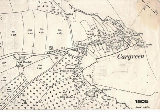
3. Everyone knewing their place, and possibly happier for it. The village women dropping a curtsy to the ladies from Park, Wayton and Penyoke. The occasional trip to Plymouth by ferry across the Tamar, up the hard to Thorn Point then trek up to Bere Ferrers Station and the steam train of the London and South Western Railway panting its way south. The Royal Oak then a real "local", vying for support with the Baptist Chapel in the village; Wesleyans and Church folk had a longer walk to their place of worship! Allotment gardens up Coombe Lane, chickens and cows sharing Cargreen's Fore Street with the villagers. A place of peace and quiet, with memories of past mining and the exodus of relations to foreign parts. The Manure Works on the riverside at Cargreen then disused. The carpenter, the blacksmith and the village shop providing peoples' everyday needs.
4. How and why has Cargreen and Landulph changed since and what is to be its future?
5. Like most agricultural villages in Cornwall Cargreen grew very slowly over many decades, probably getting a boost from the needs of hungry miners when mining in the Gunnislake area reached its peak in the mid 1800's. The collapse of the mining industry led to Cornwall suffering a declining population for virtually a hundred years from 1851 on, with a very depressing effect on the mining villages. Landulph suffered as well, with problems in farming in the 1850's coupled with those of mining, thousands left Cornwall for foreign parts, and Landulph's population steadily dropped from 590 people in 1811 to 484 in 1901.
6. Landulph Parish, and Cargreen, changed comparatively little physically over the first fifty years of the twentieth century. A few extra houses had appeared in the countryside by 1953, four council houses had been built near Cargreen but in the village only one house was added. The roads had been tarmac'd by 1953, cars and tractors were no longer a rarity, greenhouses and garages had appeared in the village, but the Royal Oak, the cottages and the orchards remained. The Parish and the village were still agricultural but the numbers of people employed on the farms and market gardens, and in fishing, had dropped with the population. From 478 people in 1911 the Parish population fell steadily to 389 in 1951.
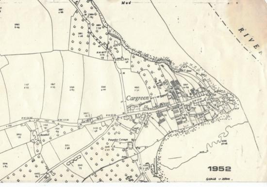
7. The Town and Country Planning Act, 1947, required County Councils to carry out surveys of their areas and to produce "Development Plans" to show proposals for the County over a 20-year period. The Cornwall Plan was prepared in the early 1950's when the population and work in farming, quarrying, and fishing were all declining and it was becoming increasingly difficult to support village schools, shops, roads, etc., with less people to pay for them.
8. The Development Plan listed villages in three categories, "A", "B", or "C" depending on their importance and their ability to support further growth because of their size or the existance of schools, etc. The "A" villages were regarded as suitable for most growth and "B" for less. Cargreen was, and still is, included within the "C" villages which the Approved Development Plan described as "centres which are suitable only for the location of a very limited number of additional dwellings".
9. Although villages like Cargreen were "scheduled" for very little growth, local Councils were particularly concerned the 1950's and 60's to try to halt the decline in rural population and at the same time to be able to support the existing schools, shops, and other services needed by villagers, and to make the provision of water and sewerage schemes more viable.
10. Cargreen was then in the St. Germans Rural District Council area, a District that had seen severe decline in its area particularly around Gunnislake and Callington. Accordingly when a planning application was submitted in 1963 for housing development on both sides of Coombe Lane (4.3 acres in all) the proposal was supported. At that time there were water supply problems but this was not felt to be an adequate reason to resist the development from a planning point of view, and permission was granted in January, 1964. As a result of this permission 24 bungalows were built.
11. The completion of the Tamar road bridge at Saltash in 1961 led to an increase in the number of new bungalows and houses being built in Caradon, particularly in Saltash. The improved access to Plymouth, coupled with easier mortgages and the ability of moro people to buy their own dwellings, the ability to afford a car, people wanting to move into the County to retire or to live in the country, led to this pressure for new housing becoming virtually an explosion. Between 1961 and 1967 the rate of building new houses in St. Germans Rural District doubled, and then doubled again from 1967 to 1973.
12. Cargreen, like so many Cornish villages, quiet, and slow growing until the 1960's, felt this pressure for development and by the end of 1975 had 40 newer dwellings, virtually doubling the size of the village. With the numbers of jobs still declining in the rural areas the village steadily changed its function from an agricultural centre to that of a dormitory village with people working further and further afield, resulting in more and more cars on the narrow twisting approach roads.
13. The Cornwall River Authority became increasingly concerned in the late 1960's about the amount of land given planning permission in Cargreen, which would all be served by an existing sewer going straight into the river, and in December 1971 requested that an embargo be put on new development in the village until such time as a contract had been signed for a new sewage treatment works. Permissions already granted however allowed some development to continue for a while.
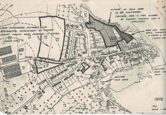
14. In 1971 the St. Germans R.D.C. were the sewerage authority, and following the River Authority's request for a building embargo put in hand surveys necessary for the design and construction of a sewage treatment works for the village. One of the first questions to be answered was how many more houses the works would need to serve, beyond those already built or to be built on land then having planning permission. The then Cornwall County Council agreed with the R.D.C., who in turn consulted the Parish Council, that about 11.5 acres should be scheduled for housing development, this acreage including 4 acres which has since been built on on the west side of Coombe Lane. The extra 7.5 acres included two fields immediately to the west of the new bungalows in Coombe Drive, land between the village and Rosehill, and two small sites near Penyoke Cottage.
15. Cornwall County Council's Development Plan and General Purposes Sub-Conmittee considered the scheduling of these extra area for housing on 29th November, 1972, and resolved that "the additional areas be considered for release for residential development when the sewerage embargo at Cargreen is lifted".
16. Before the R.D.C. could proceed with the new sewage treatment works, local goverment reorganisation took place in April, 1974, and theresponsibility for providing treatment works passed to the South West Water Authority. Due to existing development programmes for new works, deficiencies of existing works, and higher priorities for works elsewhere, no new works is likely to be provided in Cargreen for the foreseeable future.
Applications in the area between Fore Street, Cargreen Coombe Lane and the River Tamar
17 - 41. The article details a number of planning applications between December 1974 and July 1978 which were all turned down.
42. At its Meeting on the 7th August, 1978, Caradon's Planning Committee decided to inspect the village and its approach road, and to hold a public meeting to discuss the future of the area in the light of the County Structure Plan and the local census recently carried out.
The Census
43. In order to prepare a plan for the future of Cargreen it was felt necessary to find out something about the people living in the Parish, and their needs, rather than rely on the 1971 National Census which has limited use on a very local scale.
44. Census-type leaflets were distributed throughout the Parish earlier this year by the Parish Council, the leaflet containing questions relating to age, how long people had lived in the Parish, where they worked, shopped, etc.,whether they owned a car and had somewhere to put it, whether it was felt that the village should continue to grow and if there was a local need for housing, the need for a public car park,etc..
45. Of the 166 houses in the Parish replies to the Cunsus were received from 88, ie. about 50%. Of these 166 properties, 101 are in or very close to Cargreen from which 66 replies were received. Censuses of this non-statutory type tend to have a fairly low response rate but it was hoped that in caring for the Pariah and its future more residents would have replied. However, the individual's desire for privacy is respected.
46. Of the 88 householders who replied, 34 had lived in the Parish for less than 5 years, and a further 10 for less than 10 years, i.e. half of those replying were relative "newcomers" to the area, 15 replies were from residents who had lived in the Parish all their lives.
47. Of the 88 respondents, 12 had moved to the Parish from Plymouth, 24 from other parts of Britain outside Cornwall, and 5 from outside the U.K., 26 had moved from other parts of Caradon, 23 worked in the Parish, 9 in Saltash, 35 in Plymouth, 5 in Callingtoa, 31 were non-working households.
48. 61 of the householders owned their dwellings, 27 rented accommodation.
49. 46 of the residents in the village, and 14 outside the village, were in favour of a public car park being provided but the preference was for this to be sited outside the village, 21 were against provision of such a car park.
50. 78 of those replying owned a car, 9 did not. 10 householders had no space in which to put a car.
51. In answer to the question as to whether more housing should be built in the village, 51 residents said no, 5 yes, 9 yes - for local persons, 10 yes - a limited number, 7 yes - Council housing, 3 yes - infilling only, or when access and sewerage were improved.
52. 12 residents identified a general local need for housing, but only 4 were able to point out specific needs. The high cost of renting or buying local properties was emphasised, together with the movement from the village of young people who could not get or afford a dwelling.
53.Shopping habits showed that 34 households did their daily shopping in Cargreen, while for weekly shopping this fell to 7. 61 local households did their weekly shopping in Saltash, 12 in Plymouth.
54. Virtually all who replied were members of a local club, or the Church. 73 residents felt that there are adequate recreational facilities in the area, 7 that the facilities are inadequate, 4 that the playing field should be improved.
55. The Parishioners underlined the advantages of living in a beautiful area, and the peace and quiet of the Parish. Points raised in the replies to the Census also included:-
- Pollution due to lack of sewage treatment.
- Difficulties of water supply.
- Narrow local roads.
- Inadequate and expensive bus services.
- Lack of housing at reasonable cost or rental.
- Problem of holiday homes.
- Intrusion of pylons and cables.
- Lack of local jobs.
- River access need improvement for villagers.
- Rich farming land used for housing.
- Cars parking in main village street,
- Disturbance from Spaniards Inn.
- River bank erosion.
- Need for public toilets.
The Structure and Local Plan situation
56. The Draft Structure Plan for Cornwall has yet to be published by the County Council, but it will include proposals illustrating the need in the Saltash area for jobs and housing until the year 1991.
57. It will be Caradon Distriot Council's responsibility to ensure, in line with County Council and Central Government policies, to prepare Local Plans showing how, when, and where these jobs and houses can be provided.
58. It would seem that Landulph Parish should play little part in the general provision of housing and is not suitable for general industrial deveLopment because of the high amenity value of the area, the lack of public facilities, and the poor road approach.
59. The older part of Cargreen appears to be worthy of being designated as a Conservation Area, and it is possible that much of the Parish may be included as an Area of Outstanding Natural Beauty.
60. To preserve the village as it is is a natural reaction by those who do not like any change, or have recently moved to the area and their concern is to protect what there is which means preventing others from moving into the area. A village is a living organism which if contained too severely may die. Like so many villages in Britain the function of the village has changed, but there appears to be no reason to permit further extensive development so as to prevent rural depopulation and support services. The Census shown that even though the village has received some new development, a considerable number of people do not shop there while they have the freedom to shop elsewhere.
61. It should be remembered that planning in this country takes place in a democracy, in which speculative builders, so often criticised in the Census, play an important part in the housing development field. The Planning Authorities, therefore, have to acknowledge the right of any person or Company to submit any number of applications for any type of development on any piece of land whether it be scheduled for a particular purpose or not.
62. In the case of Cargreen, the County and District Councils have to decide the particular application at present under consideration and if possible agree on a policy for the future of the village. I have, therefore, set out under specific headings the issues that I feel need resolving:-
63. The Site
64 - 67. Housing
68 - 70. Parking
71 - 72. Sewage and Water Supply
73 - 75. Recreation
76. Education
77 - 78. Highways
79. Industry
80 - 82. General Amenities
83. General policies for the Parish
Conclusion
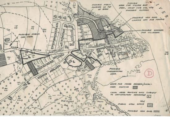
The attached plan (D) of Cargreen village is intended for discussion only and has not been discussed by any Council.
© D. Brown, Local Plans Officer, Caradon District Council. 1978, All rights reserved.
This article is protected by copyright - please contact editor@landulph.org.uk if you want to use it.

History of Landulph
- The Legend of Tamara
- Smuggling in the Tamar Valley
- The Medieval Port of Landulph
- Local Mines
- Kingsmill
- St Dilpe and the Celtic Foundation of Landulph Church
- Cornwall For Ever
- The Parish of Landulph
Millennium Project
- Landulph Millennium Photographic Project
- Panel a: Introduction
- Panel b: Church
- Panel c: Chapel
- Panel d: School
- Panel e: Landulph Memorial Hall
- Panel e: Landulph Memorial Hall continued
- Parish Millennium Map
History of Cargreen
Buildings
- History of Landulph Memorial Hall
- History of Landulph Methodist Church
- History of 1914/18 War Memorial Clock